1661. K. u. K. Militärgeneralgouvernement in Polen. [B XI c 127]
Institute and Museum of Military History •
B XI c
•
B XI Oroszország
•
B I–XV. Európa
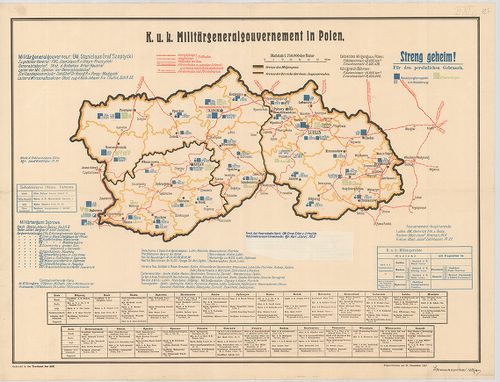
| Title | K. u. K. Militärgeneralgouvernement in Polen. |
| Main title | A császári és királyi Katonai Főkormányzóság Lengyelországban 1917. XII. 31. |
Technical features: H n 1918 Druckerei des AOK
1662. Triangulation pour relier le réseau Russe de Turkestan avec ... [B XI c 170]
Institute and Museum of Military History •
B XI c
•
B XI Oroszország
•
B I–XV. Európa

| Title | Triangulation pour relier le réseau Russe de Turkestan avec le réseau des Indes. IV. |
| Main title | Oroszország és Turkesztán háromszögelési pontjai 1890 körül. |
1663. Carte des environs de la station astronomique de Tchardiui. [B XI c 171]
Institute and Museum of Military History •
B XI c
•
B XI Oroszország
•
B I–XV. Európa
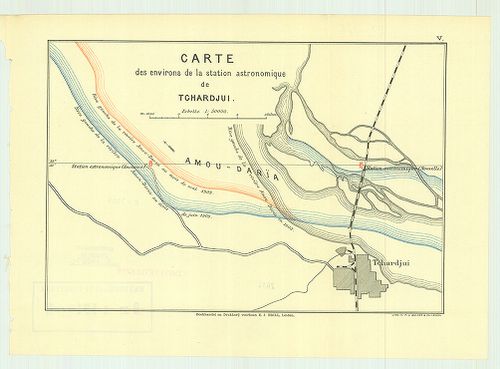
| Title | Carte des environs de la station astronomique de Tchardiui. |
| Main title | Csardzsou város környékén lévő csillagászati állomások térképe 1890 körül. |
1664. Carte des environs de la station astronomique de Tchardjui. ... [B XI c 172]
Institute and Museum of Military History •
B XI c
•
B XI Oroszország
•
B I–XV. Európa

| Title | Carte des environs de la station astronomique de Tchardjui. I. |
| Main title | Plan de la station astronomique de Tchardjui. II. |
| Subject | Csardzsou város környékén lévő csillagászati állomás és környéke 1890 körül. |
1665. Dislokation der Truppen und Anstalten im Gouvernementbereich... [B XI c 265]
Institute and Museum of Military History •
B XI c
•
B XI Oroszország
•
B I–XV. Európa
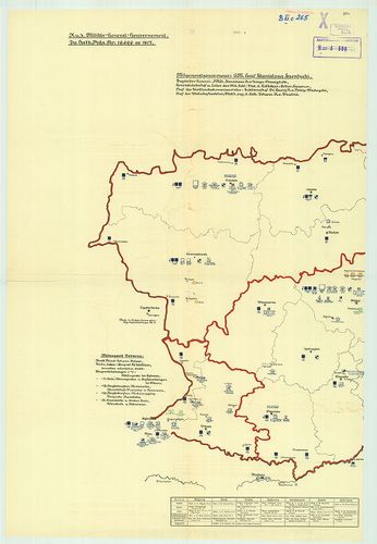
| Title | Dislokation der Truppen und Anstalten im Gouvernementbereiche. |
| Main title | A csapatok és intézmények diszlokációja. |
Technical features: Lublin 1917 Buchdr des M G G
1666. Etnographisch-geographische Karte des Nördlichen Ural Gebiet... [B XI c 268]
Institute and Museum of Military History •
B XI c
•
B XI Oroszország
•
B I–XV. Európa
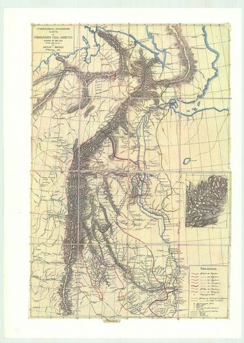
| Title | Etnographisch-geographische Karte des Nördlichen Ural Gebietes |
| Main title | Az Észak-Ural néprajzi és földrajzi térképe. |
1667. Eisenbahnkarte v.[on] Russland u.[nd] Ukraine. Aufgelegt im ... [B XI c 271]
Institute and Museum of Military History •
B XI c
•
B XI Oroszország
•
B I–XV. Európa
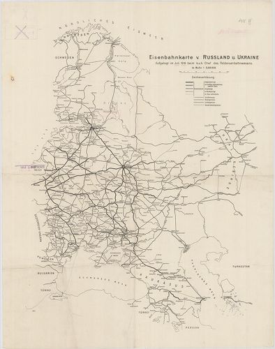
| Title | Eisenbahnkarte v.[on] Russland u.[nd] Ukraine. Aufgelegt im Juli 1918. beim K. u. k. Chef des Feldeisenbahnwesens. |
| Main title | Oroszország és Ukrajna vasúti térképe, Norvégia-Perzsia (Irán) Keleti-tenger–Ural-hegység közötti térségben. |
1668. Die Ausgestaltung des russischen Eisenbahnnetzes Während des... [B XI c 274]
Institute and Museum of Military History •
B XI c
•
B XI Oroszország
•
B I–XV. Európa
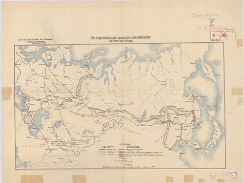
| Title | Die Ausgestaltung des russischen Eisenbahnnetzes Während des Krieges Karte 3. |
| Main title | Az orosz vasúthálózat térképe az első világháború idején. |
Technical features: H n 1918 Chef des Generalstabes des Feldheeres Abteilung Fremde Heere 1 [...]
1669. Übersichtskarte des nördlichen Kriegsschauplatzes mit den im... [B XI c 283]
Institute and Museum of Military History •
B XI c
•
B XI Oroszország
•
B I–XV. Európa
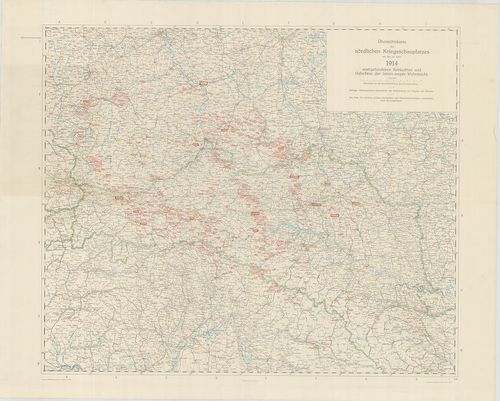
| Title | Übersichtskarte des nördlichen Kriegsschauplatzes mit den im Jahre 1914. stattgefundenen Schlachten und Gefechten der Österr.–ungar. Wehrmacht. |
| Main title | Az északi hadszíntér áttekintő térképe. |
1670. Magyarország vízierői. – Les puissances Hydrauliques de la H... [B XV b 21]
Institute and Museum of Military History •
B XV b
•
B XV Magyarország (1920 után)
•
B I–XV. Európa
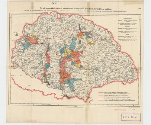
| Title | Magyarország vízierői. – Les puissances Hydrauliques de la Hongrie. – Waterpower of Hungary. Két térkép egy lapon. |
| Main title | Az új határokkal átvágott ármentesítő és lecsapoló társulatok területének térképe. – Territoires des sociétés d’endiguement et de desséchement coupés par la frontiére projetěe. – Teritoires of the flood prevencion and drainage societies cut Ihraugh by the contemplated frontier. |
1671. Hongrie carte synoptique des forets et des bassins des cours... [B XV b 70]
Institute and Museum of Military History •
B XV b
•
B XV Magyarország (1920 után)
•
B I–XV. Európa
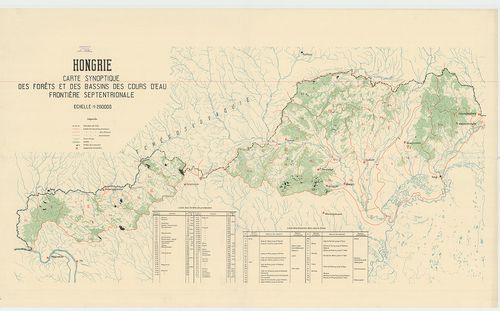
| Title | Hongrie carte synoptique des forets et des bassins des cours d’eau frontičre septentrionale. |
| Main title | Észak-Magyarország: Ipoly, Sajó, Bodrog vízgyűjtőmedencék és erdők vízgyűjtő területe. |
1672. A Magyarországi és a határmenti vízi társulatok térképe. – C... [B XV b 79]
Institute and Museum of Military History •
B XV b
•
B XV Magyarország (1920 után)
•
B I–XV. Európa
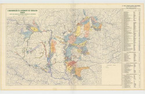
| Title | A Magyarországi és a határmenti vízi társulatok térképe. – Carte des syndicats Hydriques Hongrois et Limitrophes. |
1673. A Tiszántúl talajtájegységei. – Bodenprovinzen des Transtisz... [B XV b 138]
Institute and Museum of Military History •
B XV b
•
B XV Magyarország (1920 után)
•
B I–XV. Európa
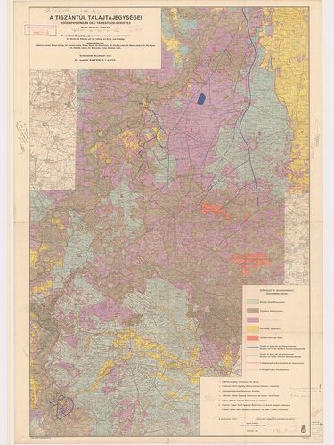
| Title | A Tiszántúl talajtájegységei. – Bodenprovinzen des Transtisza-Gebietes. |
1674. A Kőszeg-Rohonci hegység keleti részének geológiai térképe. ... [B XV b 269]
Institute and Museum of Military History •
B XV b
•
B XV Magyarország (1920 után)
•
B I–XV. Európa
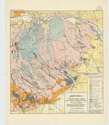
| Title | A Kőszeg-Rohonci hegység keleti részének geológiai térképe. – Geologische Karte der Osthälfte des Kőszeg-Rechnitzer Gebirges |
1675. Pétervására és Salgótarján közötti terület földtani térképe.... [B XV b 270]
Institute and Museum of Military History •
B XV b
•
B XV Magyarország (1920 után)
•
B I–XV. Európa
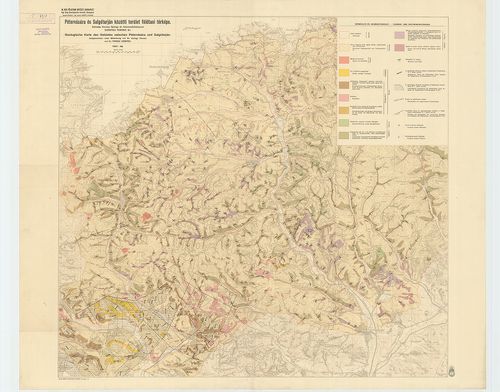
| Title | Pétervására és Salgótarján közötti terület földtani térképe. – Geologische Karte des Gebietes zwischen Pétervására und Salgótarján. |
1676. A Cserhát-hegység földtani térképe. – Geologische Karte des ... [B XV b 271]
Institute and Museum of Military History •
B XV b
•
B XV Magyarország (1920 után)
•
B I–XV. Európa
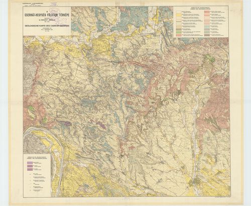
| Title | A Cserhát-hegység földtani térképe. – Geologische Karte des Cserhát-Gebirges. |
1677. Az Esztergom vidéki szénbányák környékének bányaföldtani tér... [B XV b 272]
Institute and Museum of Military History •
B XV b
•
B XV Magyarország (1920 után)
•
B I–XV. Európa
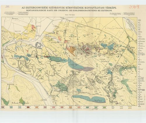
| Title | Az Esztergom vidéki szénbányák környékének bányaföldtani térképe. – Montangeologische Karte dem Umgebung des Kohlenbergbaurevieres bei Esztergom. |
1678. A Csinger völgy bányaföldtani térképe. – Montangeologische K... [B XV b 277]
Institute and Museum of Military History •
B XV b
•
B XV Magyarország (1920 után)
•
B I–XV. Európa
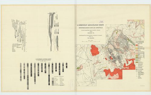
| Title | A Csinger völgy bányaföldtani térképe. – Montangeologische Karte des Csingertales. |
1679. Budapest székesfőváros dunajobbparti részének hidrogeológiai... [B XV b 279]
Institute and Museum of Military History •
B XV b
•
B XV Magyarország (1920 után)
•
B I–XV. Európa
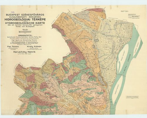
| Title | Budapest székesfőváros dunajobbparti részének hidrogeológiai térképe. Hydrogeologische Karte des am rechten Donauufer gelegenen Teiles von Budapest. |
| Main title | Mt.: Budapest... [Buda] kerületi beosztása. |
1680. A Gerecse hegység északnyugati részének földtani térképe. – ... [B XV b 283]
Institute and Museum of Military History •
B XV b
•
B XV Magyarország (1920 után)
•
B I–XV. Európa
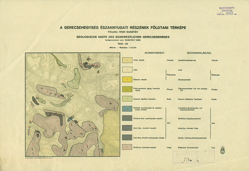
| Title | A Gerecse hegység északnyugati részének földtani térképe. – Geologische Karte des Nordwestlichen Gerecsegebirges. |