1681. A tatabányai szénmedence bányaföldtani térképe. – Montangeol... [B XV b 285]
Institute and Museum of Military History •
B XV b
•
B XV Magyarország (1920 után)
•
B I–XV. Európa
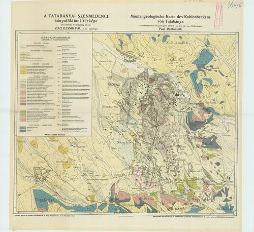
| Title | A tatabányai szénmedence bányaföldtani térképe. – Montangeologische Karte des Kohlenbeckens von Tatabánya. |
1682. A Mecsek hegység földtani térképe. – Geologische Karte des M... [B XV b 288]
Institute and Museum of Military History •
B XV b
•
B XV Magyarország (1920 után)
•
B I–XV. Európa
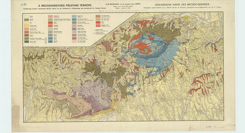
| Title | A Mecsek hegység földtani térképe. – Geologische Karte des Mecsek-Gebirges. |
1683. A Rudabányai hegység geológiai térképe. – Geologische Karte ... [B XV b 289]
Institute and Museum of Military History •
B XV b
•
B XV Magyarország (1920 után)
•
B I–XV. Európa
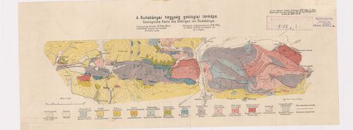
| Title | A Rudabányai hegység geológiai térképe. – Geologische Karte des Gebirges von Rudabánya. Rajz: Pitter T. |
1684. A Tiszántúl. A Magyar Tájak Földtani Leírása VI. [B XV b 294]
Institute and Museum of Military History •
B XV b
•
B XV Magyarország (1920 után)
•
B I–XV. Európa
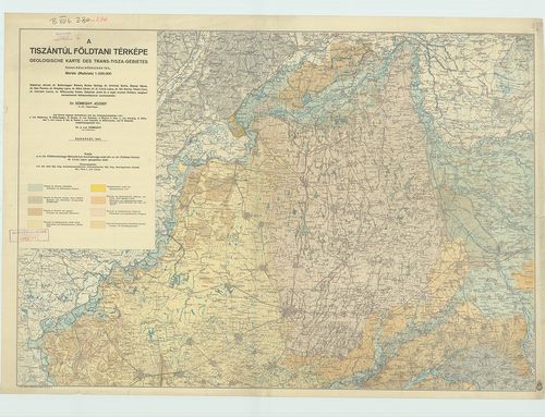
| Title | A Tiszántúl. A Magyar Tájak Földtani Leírása VI. |
| Main title | Mell.: A Tiszántúl földtani térképe. Geologische Karte des Trans-Tisza-Gebietes (É+D-i rész) |
1685. Ágostonhalmi-Kurjantói rétségek és a Kolom-tó talajtérképe. ... [B XV b 333]
Institute and Museum of Military History •
B XV b
•
B XV Magyarország (1920 után)
•
B I–XV. Európa
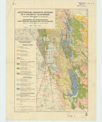
| Title | Ágostonhalmi-Kurjantói rétségek és a Kolom-tó talajtérképe. [Fülöpszállás környéke.] – Bodenkarte des Wiesengebietes Ágostonhalma-Kurjantó und des Kolom-Sees. |
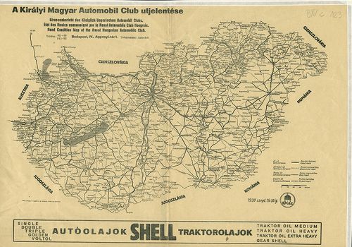
1686. A Királyi Magyar Automobil Club útjelentése. – Strassenberic... [B XV c 60]
Institute and Museum of Military History •
B XV c
•
B XV Magyarország (1920 után)
•
B I–XV. Európa
| Title | A Királyi Magyar Automobil Club útjelentése. – Strassenbericht des Königlich Ungarischen Automobil Clubs. – Road Condition Map of the Royal Hungarian Automobile Club. – État des Routes communiqué par le Royal Automobile Club Hongrois. |
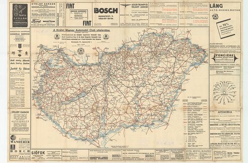
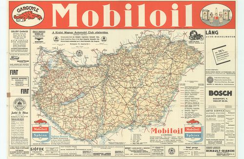
1687. A Királyi Magyar Automobil Club útjelentése. [Magyarország.]... [B XV c 123]
Institute and Museum of Military History •
B XV c
•
B XV Magyarország (1920 után)
•
B I–XV. Európa
| Title | A Királyi Magyar Automobil Club útjelentése. [Magyarország.] – Strassenbericht des Königlich Ungarischen Automobil Clubs. – État des Routes communiqué par la Royal Automobile Club Hongrois. – Road Condition Map of the Royal Hungarian Automobile Club. |
1688. A Királyi Magyar Automobil Club útjelentése. 1932. augusztus... [B XV c 130]
Institute and Museum of Military History •
B XV c
•
B XV Magyarország (1920 után)
•
B I–XV. Európa
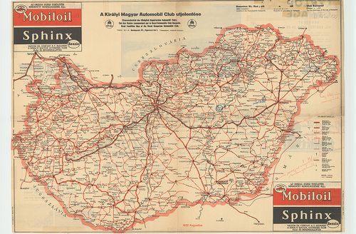
| Title | A Királyi Magyar Automobil Club útjelentése. 1932. augusztus. [Magyarország.] – Strassenbericht des Königlich Ungarischen Automobil Clubs. – État des Routes communiqué par le Royal Automobile Club Hongrois. – Road Condition Map of the Royal Hungarian Automobile Club. |
| Main title | Hátl.: [Budapesti látképrészlet.] |
1689. A Királyi Magyar Automobil Club útjelentése. Strassenbericht... [B XV c 133]
Institute and Museum of Military History •
B XV c
•
B XV Magyarország (1920 után)
•
B I–XV. Európa
| Title | A Királyi Magyar Automobil Club útjelentése. Strassenbericht… – Road Condition… – État des Routes… |
| Main title | Magyarország útállapottérképe 1936-ban. |
1690. A Királyi Magyar Automobil Club útjelentése. 1934. május. – ... [B XV c 138]
Institute and Museum of Military History •
B XV c
•
B XV Magyarország (1920 után)
•
B I–XV. Európa

| Title | A Királyi Magyar Automobil Club útjelentése. 1934. május. – Strassenbericht… Road Condition…État des Routes… |
| Main title | Magyarország útállapottérképe 1934-ben. |
1691. A Magyar Királyi Államvasutak vonalhálózata. – Das Liniennet... [B XV c 160]
Institute and Museum of Military History •
B XV c
•
B XV Magyarország (1920 után)
•
B I–XV. Európa
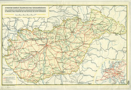
| Title | A Magyar Királyi Államvasutak vonalhálózata. – Das Liniennetz der Kőniglich Ungarischen Staatsbahnen. – Le Réseau des Chemins de fer Royaux de l’état Hongrois. |
| Main title | Mt. [Európa nemzetközi vasútvonalai.]Magyarország vasúthálózata 1940-ben. |
1692. 1. Carte ethnique du territoire au sud de Nyitra. Fin du XVI... [B XV c 450]
Institute and Museum of Military History •
B XV c
•
B XV Magyarország (1920 után)
•
B I–XV. Európa
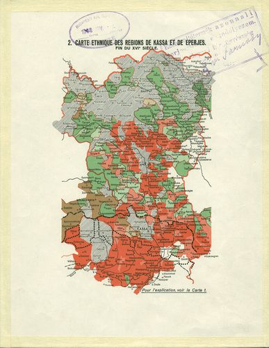
| Title | 1. Carte ethnique du territoire au sud de Nyitra. Fin du XVI.-e sičcle. |
| Main title | 2. Carte ethnique des regions de Kassa et de Eperjes. Fin du XVI-e sičcle. |
| Subject | (Az 1938. X. 8-án kért és a X. 22-én felajánlott határokkal.) Nyitra , Kassa és Eperjes környékének néprajzi térképe 1938-ban. |
1693. Carte ethnografique du territoire de la Hongrie historique d... [B XV c 461/2]
Institute and Museum of Military History •
B XV c
•
B XV Magyarország (1920 után)
•
B I–XV. Európa

| Title | Carte ethnografique du territoire de la Hongrie historique d’aprés les recensements de 1930–1939. |
| Main title | A történelmi Magyarország területének nemzetiségi térképe az 1930–1939-es népszámlálások alapján. |
Technical features: Budapest 1940 Inst des Sciences polit de la Société [...]
1694. Nationalitätkarte des Gebietes vom geschichtlichen Ungarn. N... [B XV c 461/4]
Institute and Museum of Military History •
B XV c
•
B XV Magyarország (1920 után)
•
B I–XV. Európa

| Title | Nationalitätkarte des Gebietes vom geschichtlichen Ungarn. Nach den Volkszählungen aus den Jahren 1930–1939. |
| Main title | A történelmi Magyarország területének nemzetiségi térképe az 1930–1939-es népszámlálások alapján. |
1695. Carte ethnographique de la Frontiére Linguistique Hungaro-Sl... [B XV c 467/1]
Institute and Museum of Military History •
B XV c
•
B XV Magyarország (1920 után)
•
B I–XV. Európa
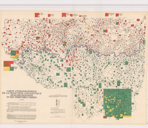
| Title | Carte ethnographique de la Frontiére Linguistique Hungaro-Slovaque et des Territoires Voisins. I. Partie. |
| Main title | A magyar–szlovák nyelvhatár vidékének és a szomszédos területeknek nemzetiségi térképe francia nyelven. |
Technical features: Budapest 1942 Institut des Sciences Politiques Ny Inst Géographiques [...]
1696. Nationalitätenverhältnisse des ungarisch–slowakischen Grenzr... [B XV c 467/2]
Institute and Museum of Military History •
B XV c
•
B XV Magyarország (1920 után)
•
B I–XV. Európa
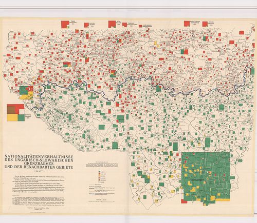
| Title | Nationalitätenverhältnisse des ungarisch–slowakischen Grenzraumes und der Benechbarten Gebiete. I.–II. Blatt. |
| Main title | A magyar–szlovák nyelvhatár vidékének és a szomszédos területeknek nemzetiségi térképe német nyelven. |
1697. I. Mátrabánya bányatérképe. – Übersichtskarte der Bergbauver... [B XV c 550]
Institute and Museum of Military History •
B XV c
•
B XV Magyarország (1920 után)
•
B I–XV. Európa
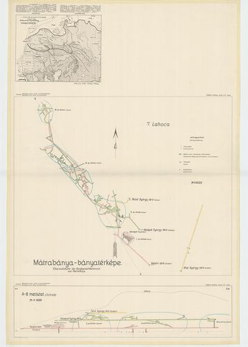
| Title | I. Mátrabánya bányatérképe. – Übersichtskarte der Bergbauverhältnisse von Mátrabánya. |
| Main title | Vitalis: Mátrabánya arany-, ezüst- és rézércbányászata. III. Schafarzik Ferenc: Völgyképződés a Budai hegység déli részében. – Talbildung im südl. Teile des Ofner Gebirger. |
| Subject | „Földtani közlöny. Band LVI. kötet mellékletei.” |
1698. Carte Synomtique des Surfaces Dénudées Situées en Hongrie et... [B XV c 565]
Institute and Museum of Military History •
B XV c
•
B XV Magyarország (1920 után)
•
B I–XV. Európa
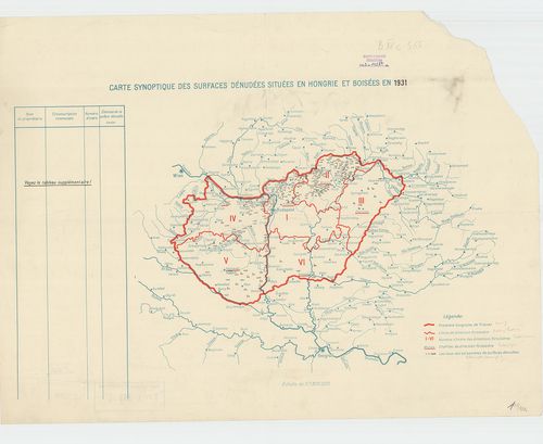
| Title | Carte Synomtique des Surfaces Dénudées Situées en Hongrie et Boisées en 1931. |
| Main title | Magyarország fakitermelésének áttekintő térképe 1931-ben. |
1699. Carte Synoptique des Surfaces Dénudées situées en Hongrie et... [B XV c 595]
Institute and Museum of Military History •
B XV c
•
B XV Magyarország (1920 után)
•
B I–XV. Európa
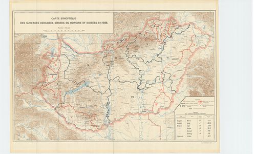
| Title | Carte Synoptique des Surfaces Dénudées situées en Hongrie et Boisées en 1938. |
| Main title | Magyarország fakitermelésének térképe 1938-ban. |
1700. [Magyarország.] Az élveszületési arány alakulása Magyarorszá... [B XV c 793]
Institute and Museum of Military History •
B XV c
•
B XV Magyarország (1920 után)
•
B I–XV. Európa

| Title | [Magyarország.] Az élveszületési arány alakulása Magyarország községeiben. (Az 1934–36. évek átlagában.) – Variations des Proportions des Naisances vivantes dans les Communes de Hongrie (Moyennes pour 1934–36.) |
| Main title | Mt.: Nagy-Budapest. |