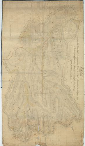
5221. Sigeth. [G I h 657/13]
Institute and Museum of Military History •
G I h vár alaprajzok, város és környéktérképek, utikönyvek
•
G I Európa
•
G I–V. Úti térképek

| Title | Sigeth. |
| Main title | Szigetvár alaprajza 1751-ből. |
Technical features: [...] Les Plans Vuës Et Perspectives Des Villes Chateaux
5222. Übersichtskarte der Dolomiten. I. Blatt. [B IX c 477/2]
Institute and Museum of Military History •
B IX c
•
B IX Ausztria–Magyarország
•
B I–XV. Európa
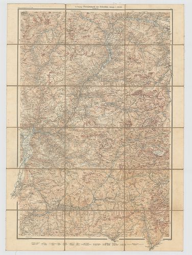
| Title | Übersichtskarte der Dolomiten. I. Blatt. |
| Main title | A Dolomitok áttekintőtérképe 1913-ban. |
Technical features: [...] szv Sziklarajzos Jelm Vv Zeitschrift des D und Ö A V [...]
5223. Südost-Europa. [B II c 116]
Institute and Museum of Military History •
B II c
•
B II Európa, nagyobb részek és országcsoportok
•
B I–XV. Európa
| Title | Südost-Europa. |
| Main title | Délkelet-Európa autótérképe. |
Technical features: [...] Geogr Inst Ed Hölzel ÖAMTC des Österr Automobil Motorrad und Touring [...]
5224. [Lingen, Bentheim grófság és Arenberg-Meppen hercegség topog... [B IV a 202]
Institute and Museum of Military History •
B IV a
•
B IV Német birodalom
•
B I–XV. Európa
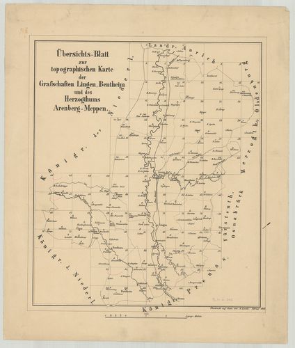
| Title | [Lingen, Bentheim grófság és Arenberg-Meppen hercegség topográfiai térképe.] |
Technical features: H n 1860 Litographischen Anstalt des Königlichen Generalstab
5225. Plan d'Aquilée, bourg bâti sur les ruines de l'ancienne metr... [S 68 - XIII. - No. 59.]
National Archives of Hungary •
S 68 Festetics család (1645-1943)
•
S Családi fondokból kiemelt térképek (17. sz.-20. sz.)
•
S – Térképtár
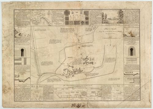
| Main title | Plan d'Aquilée, bourg bâti sur les ruines de l'ancienne metropole dont il porte le nom |
| Subject | XIII. - No. 59. Aquileia (I) |
Content: Carte du Frioul Vue des sources du Timave Vue prise [...]
5226. József főherceg pálmaháza. Üvegház. [HU BFL - XV.17.f.331.b - 1/4]
Budapest City Archives •
HU BFL XV.17.f.331.b Ybl Miklós hagyatéka, tervek (1844-1891)
•
HU BFL XV.17.f.331 Ybl Miklós hagyatéka, tervek és iratok (1844-1891)
•
HU BFL XV.17.f Építészek, vállalkozók, vállalatok, beruházók tervei (1844-2005)
•
HU BFL XV.17 - Tervtár
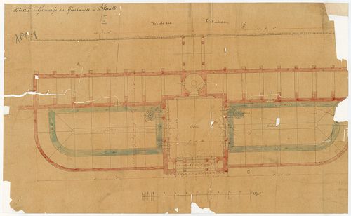
| Subject | József főherceg pálmaháza. Üvegház. |
Content: Blatt I Grundriss des Glashausses in Alcsuth
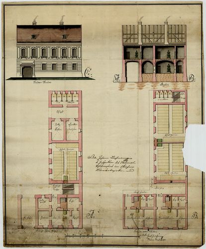
5227. Lónyay Menyhért villája. Lépcsős támfalrendszer. [HU BFL - XV.17.f.331.b - 73/26]
Budapest City Archives •
HU BFL XV.17.f.331.b Ybl Miklós hagyatéka, tervek (1844-1891)
•
HU BFL XV.17.f.331 Ybl Miklós hagyatéka, tervek és iratok (1844-1891)
•
HU BFL XV.17.f Építészek, vállalkozók, vállalatok, beruházók tervei (1844-2005)
•
HU BFL XV.17 - Tervtár
| Subject | Lónyay Menyhért villája. Lépcsős támfalrendszer. |
Content: Bau Sr Exc Des Herrn Grafen Melchior Lónyay
5228. (Sexardiensis Scholaris Domus) [S 12 - Div. IV. - No. 7.]
National Archives of Hungary •
S 12 Helytartótanácsi térképek (1738-1875)
•
S Kormányhatósági fondokból kiemelt térképek (17. sz.-20. sz.)
•
S – Térképtár
| Main title | (Sexardiensis Scholaris Domus) |
| Subject | Div. IV. - No. 7. A Szekszárdi iskola tervrajza |
Contributor: Bachmann Johann K Inspector des Nationalschulwesens in Fünfkirchner Literärbezirke
5229. Charte von den Kaiserlich Oesterreichischen Ungarischen Länd... [S 68 - X. - No. 100.]
National Archives of Hungary •
S 68 Festetics család (1645-1943)
•
S Családi fondokból kiemelt térképek (17. sz.-20. sz.)
•
S – Térképtár
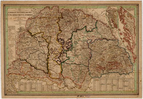
| Main title | Charte von den Kaiserlich Oesterreichischen Ungarischen Ländern |
| Subject | X. - No. 100. Magyarország |
Contributor: im Verlag des geograph Instituts
5230. Africa [S 68 - XIV. - No. 143.]
National Archives of Hungary •
S 68 Festetics család (1645-1943)
•
S Családi fondokból kiemelt térképek (17. sz.-20. sz.)
•
S – Térképtár
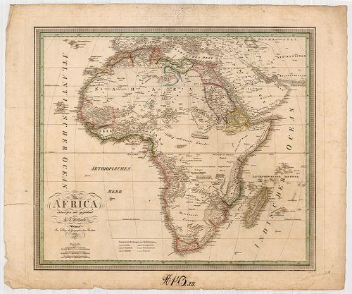
| Main title | Africa |
| Subject | XIV. - No. 143. Afrika |
Contributor: im Verlage des Geographischen Instituts
5231. Asien ... [S 68 - XIV. - No. 142.]
National Archives of Hungary •
S 68 Festetics család (1645-1943)
•
S Családi fondokból kiemelt térképek (17. sz.-20. sz.)
•
S – Térképtár
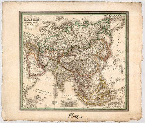
| Main title | Asien ... |
| Subject | XIV. - No. 142. Ázsia |
Contributor: im Verlge des Geogrph Instituts
5232. Die Kaiserlich Oesterreichischen Ungarischen Erbstaaten das ... [S 68 - X. - No. 86.]
National Archives of Hungary •
S 68 Festetics család (1645-1943)
•
S Családi fondokból kiemelt térképek (17. sz.-20. sz.)
•
S – Térképtár
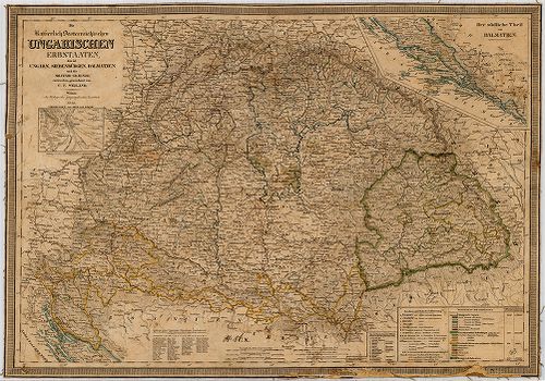
| Main title | Die Kaiserlich Oesterreichischen Ungarischen Erbstaaten das ist Ungarn, Siebenbürgen, Dalmatien und die Militair-Graenze |
| Subject | X. - No. 86. Magyarország |
Contributor: Im Verlage des Geographisches Instituts
5233. Római katolikus templom és plébánia. A grófi karzatra vezető... [HU BFL - XV.17.f.331.b - 4/123]
Budapest City Archives •
HU BFL XV.17.f.331.b Ybl Miklós hagyatéka, tervek (1844-1891)
•
HU BFL XV.17.f.331 Ybl Miklós hagyatéka, tervek és iratok (1844-1891)
•
HU BFL XV.17.f Építészek, vállalkozók, vállalatok, beruházók tervei (1844-2005)
•
HU BFL XV.17 - Tervtár
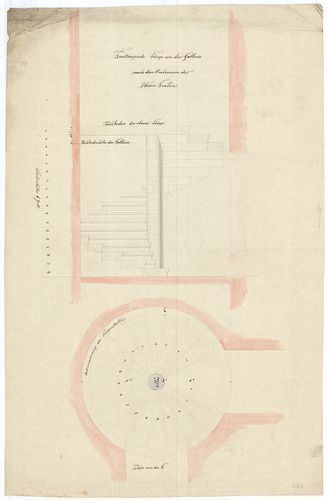
| Subject | Római katolikus templom és plébánia. A grófi karzatra vezető csigalépcső alaprajza és metszete. |
Content: [...] der Gallerie nach dem Oratorium des Herrn Grafen
5234. Felsőszigeti vendéglő. Az új terem toldalék keresztmetszete. [HU BFL - XV.17.f.331.b - 79/23]
Budapest City Archives •
HU BFL XV.17.f.331.b Ybl Miklós hagyatéka, tervek (1844-1891)
•
HU BFL XV.17.f.331 Ybl Miklós hagyatéka, tervek és iratok (1844-1891)
•
HU BFL XV.17.f Építészek, vállalkozók, vállalatok, beruházók tervei (1844-2005)
•
HU BFL XV.17 - Tervtár

| Subject | Felsőszigeti vendéglő. Az új terem toldalék keresztmetszete. |
Content: Bau Margarethen Insel Neubau des Saales an der kleinen Restauration [...]
5235. Forst Charte des Vaszarer Valdes im Veszprimer Comitat zu de... [S 14 - Div. I. - No. 155:4.]
National Archives of Hungary •
S 14 Erdőtérképek (1779-1830)
•
S Kormányhatósági fondokból kiemelt térképek (17. sz.-20. sz.)
•
S – Térképtár
| Main title | Forst Charte des Vaszarer Valdes im Veszprimer Comitat zu dem V. Raaber Bisthum gehörig ... |
| Subject | Div. I. - No. 155:4. Vaszar /Veszprém m/ határában fekvő, a Győri Püspökséghez tartozó erdő gazdálkodási térképe |
5236. Situation des in der Joseph Stadt an Ek der Prater und Renn ... [Budapest térképeinek katalógusa 1605]
Budapest City Archives •
Pest
•
Az 1873 előtti időszakra vonatkozó térképek leírása
•
Budapest térképeinek katalógusa
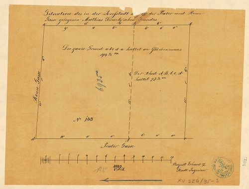
| Main title | Situation des in der Joseph Stadt an Ek der Prater und Renn Gasse gelegenen Mathias Szuszky’schen Grundes |
| Subject | A Szuszky-féle telek (mai Práter utca és Futó utca sarka) felosztási terve |
5237. Plan von den Hochgraflich Anton Joseph Batthya-nischen Hotte... [SML XV 2 a T 303]
Somogy County Archives •
Somogy megye kéziratos térképei
| Main title | Plan von den Hochgraflich Anton Joseph Batthya-nischen Hotter des Dorfes Almamellék; wie auch jenen, deren Praedien Szent Egyed, Szent Mártony, und Lukafa, nebst allen zu letzteren gehörigen Waldtheilen |
| Subject | Almamellék térképe |
5238. Tagebuch eines Generalstabsoffiziers waerend des russisch-ja... [H IV c 360/4]
Institute and Museum of Military History •
H IV c (1841–1913)
•
H IV Újabbkori háborúk
•
H Háborúk

| Title | Tagebuch eines Generalstabsoffiziers waerend des russisch-japanischen Krieges |
| Main title | Karte: IV. Zweiter russischer Angriff auf den Motienling (K.) am 17. Juli 1904. |
| Subject | Karte: V. Gefecht bei Gebato (K.) am 17. Juli 1904. |
5239. A Magyar Birodalom közjogi térképe, az 1867: II., 1868: XXX.... [B IX c 1065]
Institute and Museum of Military History •
B IX c
•
B IX Ausztria–Magyarország
•
B I–XV. Európa
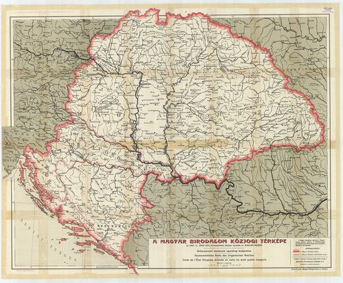
| Title | A Magyar Birodalom közjogi térképe, az 1867: II., 1868: XXX. törvénycikkek alapján. – Drzavoprani zemljovid ugarskod kraljevstva. – Staatsrechtliche Karte des Ungarischen Reiches. – Carte de l’Etat Hongrois, dressée en vertu du droit public hongrois. |
5240. Plan der regulierten Orts Laage, des in dem löbl. Csanader C... [S 11 - No. 779:1.]
National Archives of Hungary •
S 11 Kamarai térképek (1747-1882)
•
S Kormányhatósági fondokból kiemelt térképek (17. sz.-20. sz.)
•
S – Térképtár

| Main title | Plan der regulierten Orts Laage, des in dem löbl. Csanader Comitats liegenden zum löblich Arader Cameral Praefecturat, Petskaer Provisorat gehörigen Orts Sajtény |
| Subject | No. 779:1. Sajtény (Csanád m., ma Şeitin, RO) |