801. General-Karte der Markgrafschaft Mahren mit den Antheilen de... [B IX a 139]
Institute and Museum of Military History •
B IX a
•
B IX Ausztria–Magyarország
•
B I–XV. Európa
| Title | General-Karte der Markgrafschaft Mahren mit den Antheilen des Herzogthums Schlesien… |
802. Situations Plan von der Lage des Weissen Morastes und seiner... [TK 1095]
National Széchényi Library •
OSZK kéziratos térképek

| Title | Situations Plan von der Lage des Weissen Morastes und seiner Schiffbarmachung |
803. Hypsometrische Übersichts-Karte des Herzogthumes Steiermark… [B IX b 30]
Institute and Museum of Military History •
B IX b
•
B IX Ausztria–Magyarország
•
B I–XV. Európa
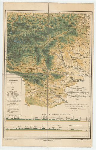
| Title | Hypsometrische Übersichts-Karte des Herzogthumes Steiermark… |
| Main title | Stájerország hipszometrikus áttekintő térképe. |
804. Ethnographische Karte des Königreichs Ungarn. [B IX c 118/1]
Institute and Museum of Military History •
B IX c
•
B IX Ausztria–Magyarország
•
B I–XV. Európa
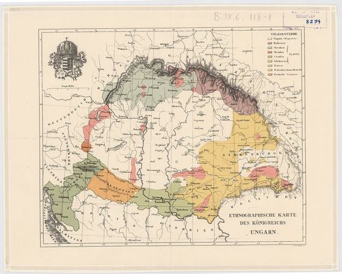
| Title | Ethnographische Karte des Königreichs Ungarn. |
| Main title | Magyarország néprajzi térképe 1846 körül. |
805. Situationsplan des Ofner Bahnhofes [Budapest térképeinek katalógusa 429]
Budapest City Archives •
Buda
•
Az 1873 előtti időszakra vonatkozó térképek leírása
•
Budapest térképeinek katalógusa
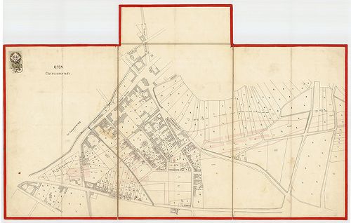
| Main title | Situationsplan des Ofner Bahnhofes |
| Subject | A Déli pályaudvar elhelyezésének terve |
806. Delineation des Liptauer Hauses [hátoldalon] [T 35 - No. 1.]
National Archives of Hungary •
T 35 Ghyczy család (18. sz.-19. sz.)
•
T Családi fondokból kiemelt tervek (1659-2000)
•
T – Tervtár
| Main title | Delineation des Liptauer Hauses [hátoldalon] |
| Subject | No. 1. Liptói /!/ ház |
807. Karte des Kaukasus. [B XI a 159]
Institute and Museum of Military History •
B XI a
•
B XI Oroszország
•
B I–XV. Európa
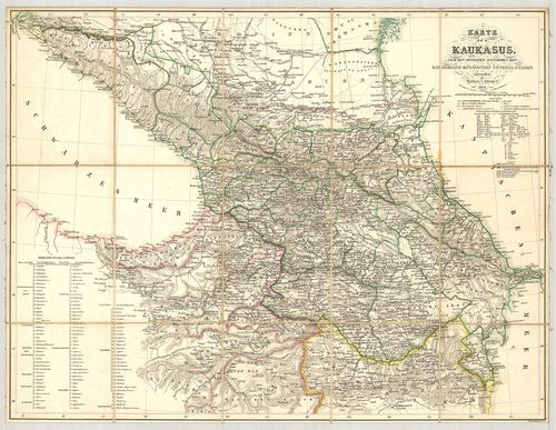
| Title | Karte des Kaukasus. |
| Main title | A Kaukázus térképe tartományi határokkal, 1842-ben. |
808. General-Karte der Markgrafschaft Máhren mit den Antheilen de... [B IX a 139]
Institute and Museum of Military History •
B IX a
•
B IX Ausztria–Magyarország
•
B I–XV. Európa
| Title | General-Karte der Markgrafschaft Máhren mit den Antheilen des Herzogthums Schlesien… |
809. Union des Républiques Socialistes Soviétiques. [B XI a 175/1]
Institute and Museum of Military History •
B XI a
•
B XI Oroszország
•
B I–XV. Európa
| Title | Union des Républiques Socialistes Soviétiques. |
| Main title | Szovjetunió közigazgatási térképe 1965-ben. |
810. Vordere und Seiten Ansicht des Hojer [T 75 - No. 528.]
National Archives of Hungary •
T 75 Erdélyi kormányhatósági levéltárakból kiemelt tervek (1783-1868)
•
T Kormányhatósági fondokból kiemelt tervek (17. sz.-20. sz.)
•
T – Tervtár
| Main title | Vordere und Seiten Ansicht des Hojer |
| Subject | No. 528. Műszer (?) |
811. A tatabányai szénmedence bányaföldtani térképe. – Montangeol... [B XV b 285]
Institute and Museum of Military History •
B XV b
•
B XV Magyarország (1920 után)
•
B I–XV. Európa
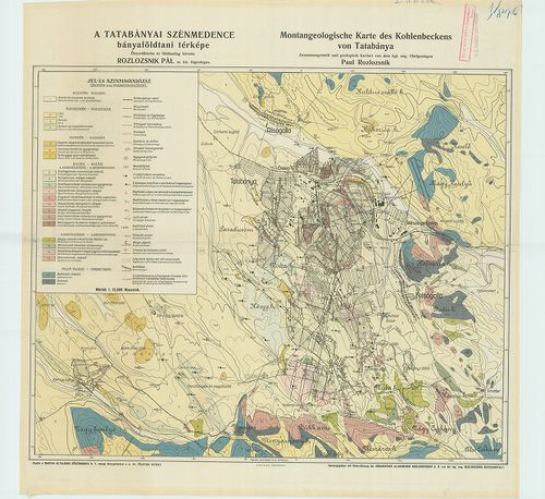
| Title | A tatabányai szénmedence bányaföldtani térképe. – Montangeologische Karte des Kohlenbeckens von Tatabánya. |
812. Situations Plan des Csik Gyimeser Contunatzortraumes [T 75 - No. 253.]
National Archives of Hungary •
T 75 Erdélyi kormányhatósági levéltárakból kiemelt tervek (1783-1868)
•
T Kormányhatósági fondokból kiemelt tervek (17. sz.-20. sz.)
•
T – Tervtár
| Main title | Situations Plan des Csik Gyimeser Contunatzortraumes |
| Subject | No. 253. Gyimes |
813. Wegkarte des Schwarzwaldes. [B IV c 252]
Institute and Museum of Military History •
B IV c
•
B IV Német birodalom
•
B I–XV. Európa
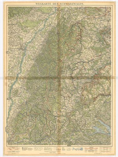
| Title | Wegkarte des Schwarzwaldes. |
| Main title | A Fekete-erdő úthálózati térképe 1930-ban. |
814. [Projekts-Pläne des Palatinallinie.] Plan „B”. [G I h 185/84]
Institute and Museum of Military History •
G I h vár alaprajzok, város és környéktérképek, utikönyvek
•
G I Európa
•
G I–V. Úti térképek
| Title | [Projekts-Pläne des Palatinallinie.] Plan „B”. |
| Main title | Komárom: A Nádorvonal tervrajza. |
815. Profile des Werkes Igmand. [G I h 185/85]
Institute and Museum of Military History •
G I h vár alaprajzok, város és környéktérképek, utikönyvek
•
G I Európa
•
G I–V. Úti térképek
| Title | Profile des Werkes Igmand. |
| Main title | Komárom: Az Igmándi-erőd keresztmetszet rajzai. |
816. [Plan des Schlosses Vason.] [G I h 729]
Institute and Museum of Military History •
G I h vár alaprajzok, város és környéktérképek, utikönyvek
•
G I Európa
•
G I–V. Úti térképek

| Title | [Plan des Schlosses Vason.] |
| Main title | A nagyvázsonyi vár alaprajza 1572-ből. |
817. Aufnahme des Carliburg Rathauses [T 75 - No. 104/1-4.]
National Archives of Hungary •
T 75 Erdélyi kormányhatósági levéltárakból kiemelt tervek (1783-1868)
•
T Kormányhatósági fondokból kiemelt tervek (17. sz.-20. sz.)
•
T – Tervtár
| Main title | Aufnahme des Carliburg Rathauses |
| Subject | No. 104/1-4. Károlyfehérvár |
818. Plan des Schlosses Szamos Ujvar. [G I h 3866]
Institute and Museum of Military History •
G I h vár alaprajzok, város és környéktérképek, utikönyvek
•
G I Európa
•
G I–V. Úti térképek
| Title | Plan des Schlosses Szamos Ujvar. |
| Main title | A Szamosújvár-i vár alaprajza. |
819. Situationsplan des Kastells zu Maros-Vasarhely. [G I h 3930]
Institute and Museum of Military History •
G I h vár alaprajzok, város és környéktérképek, utikönyvek
•
G I Európa
•
G I–V. Úti térképek
| Title | Situationsplan des Kastells zu Maros-Vasarhely. |
| Main title | A marosvásárhelyi vár alaprajza. |
820. Der siebenjährige Krieg, 1756–63. (Kriege Friedrichs des Gro... [H III e 1025/1]
Institute and Museum of Military History •
H III e (1741–1789)
•
H III Újkori háborúk (1492–1789)
•
H Háborúk

| Title | Der siebenjährige Krieg, 1756–63. (Kriege Friedrichs des Grossen 3. Theil.) |