21. No. 1/b. A Duna-mappáció mérnöki iratai [S 81 - No. 1/b.]
National Archives of Hungary •
S 81 Iratok (1779-1924)
•
S Vízrajzi Intézet (18. sz.-20. sz.)
•
S – Térképtár
| Subject | No. 1/b. A Duna-mappáció mérnöki iratai |
22. Karten der Donaustromes innerhalb der österr. Kaiserstaates. [B IX b 138]
Institute and Museum of Military History •
B IX b
•
B IX Ausztria–Magyarország
•
B I–XV. Európa
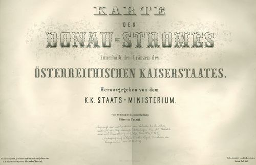
| Title | Karten der Donaustromes innerhalb der österr. Kaiserstaates. |
| Main title | A Duna Passautól Orsováig. |
Technical features: [...] Megjelent Deák A Jankó A Duna mappáció Vízrajzi és hajózási térképek a [...]
23. Donau Atlas. Hydrographische Donau Karte von Peterwardein [r... [B IX b 134]
Institute and Museum of Military History •
B IX b
•
B IX Ausztria–Magyarország
•
B I–XV. Európa
| Title | Donau Atlas. Hydrographische Donau Karte von Peterwardein [rossz cím, valójában: Pressburg] bis Orschova. |
| Main title | A Duna térképe Pozsonytól – Orsováig. |
Technical features: [...] sz hiány Ep 352 A Duna mappáció DVD n is szerepel Lásd [...]
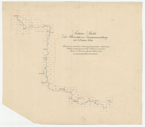
24. Uebersichts Charte, aus der zu ersehen ist, was im Jahre 182... [S 12 - Div. XIII. - No. 555.]
National Archives of Hungary •
S 12 Helytartótanácsi térképek (1738-1875)
•
S Kormányhatósági fondokból kiemelt térképek (17. sz.-20. sz.)
•
S – Térképtár

| Main title | Uebersichts Charte, aus der zu ersehen ist, was im Jahre 1823 und 1824 von der Hydrographie des Donau mappirt und was noch im oberen Districte zu mappiren übrig ist |
| Subject | Div. XIII. - No. 555. A Duna Pozsony /Pozsony m./ és Visegrád /Pest m./ közötti szakaszának munkatérképe a felmérési munkák állapotának feltüntetésével /Duna-mappáció/ |