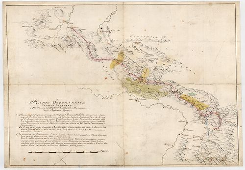
21. Mappa Geographica Lineae inter utrumque Imperium, Limitaneae... [B IX c 1434]
Institute and Museum of Military History •
B IX c
•
B IX Ausztria–Magyarország
•
B I–XV. Európa
| Title | Mappa Geographica Lineae inter utrumque Imperium, Limitaneae [...] a Confinio Triplici, usque ad Szluin [...] exhibens |
| Main title | Földrajzi térkép, amely a két birodalom között húzódó [...] határokat a hármas határtól Szluinig... mutatja. Határtérkép. |
Contributor: MARSIGLI L F MÜLLER J C [...]
22. Limitum post Pacem Carlovitcensem A MDCXCVIII. Mappa Geograp... [B IX c 1421]
Institute and Museum of Military History •
B IX c
•
B IX Ausztria–Magyarország
•
B I–XV. Európa
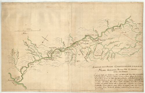
| Title | Limitum post Pacem Carlovitcensem A MDCXCVIII. Mappa Geographica, Tractus Unnae fl. Limitanei inter duo Imperia. |
| Main title | Az 1698. (sic!) évi Karlócai békeszerződés utáni határok földrajzi térképe, amely az Una folyónak a két birodalom közötti határszakaszát ábrázolja. Határtérkép. |
Contributor: MARSIGLI L F MÜLLER J C [...]
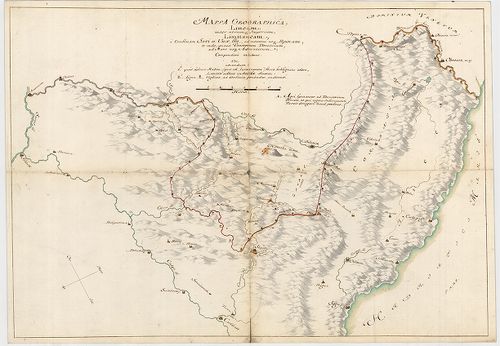
23. Mappa Geographica Unnae Fluvii Tractum, a Kastanovitz, usque... [B IX c 1422]
Institute and Museum of Military History •
B IX c
•
B IX Ausztria–Magyarország
•
B I–XV. Európa
| Title | Mappa Geographica Unnae Fluvii Tractum, a Kastanovitz, usque ad Monasterii rudera, item, Controversum adhuc Territorium Novense, exhibens. |
| Main title | Geográfiai térkép, amely az Una folyót Kastanovitztól a kolostor romjaiig, valamint a még vitatott novi-i területet ábrázolja. Határtérkép. |
Contributor: MARSIGLI L F MÜLLER J C [...]
24. Mappa Geographica; Lineam, inter utrumque Imperium, Limitane... [B IX c 1423]
Institute and Museum of Military History •
B IX c
•
B IX Ausztria–Magyarország
•
B I–XV. Európa
| Title | Mappa Geographica; Lineam, inter utrumque Imperium, Limitaneam, a Confluxu Savi et Unae ffl., ad montem usque Popinam, ad Mare usque Adriaticum; Compendiose exhibens |
| Main title | Földrajzi térkép, amely a két birodalom határvonalát a Száva és az Una folyók torkolatától a Popina hegyig, és innen a velencei fennhatóságú területekig, egészen az Adriai tengerig, vázlatosan bemutatja. Határtérkép. |
Contributor: MARSIGLI L F MÜLLER J C [...]
25. Mappa Geographica Tractus Unae fl. Limitanei inter Duo imper... [B IX c 1424]
Institute and Museum of Military History •
B IX c
•
B IX Ausztria–Magyarország
•
B I–XV. Európa
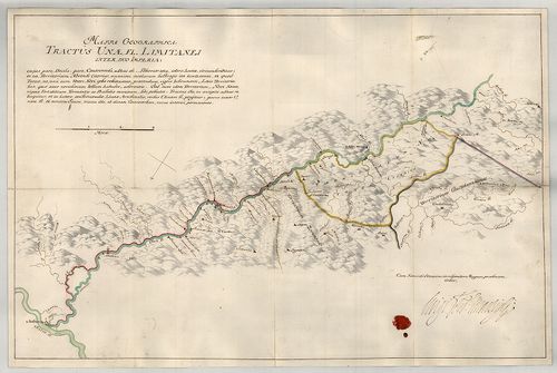
| Title | Mappa Geographica Tractus Unae fl. Limitanei inter Duo imperia... |
| Main title | Földrajzi térkép, amely az Una folyónak a két birodalom közötti szakaszát ábrázolja. Határtérkép. |
Contributor: MARSIGLI L F MÜLLER J C [...]
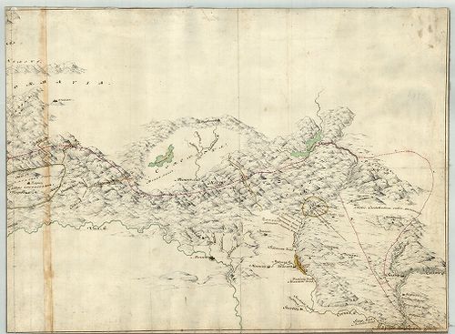
26. Mappa Geographica Tractus Limitanei a Sluin, usque ad, Tripl... [B IX c 1425]
Institute and Museum of Military History •
B IX c
•
B IX Ausztria–Magyarország
•
B I–XV. Európa
| Title | Mappa Geographica Tractus Limitanei a Sluin, usque ad, Triplicis Confinii, Punctum... |
| Main title | Szluintól a hármas határ pontjáig terjedő határszakasz geográfiai térképe... Határtérkép. |
Contributor: MARSIGLI L F MÜLLER J C [...]
27. Mappa Geographica, qua Praecautio contra Pestem instituenda ... [B IX c 1426]
Institute and Museum of Military History •
B IX c
•
B IX Ausztria–Magyarország
•
B I–XV. Európa
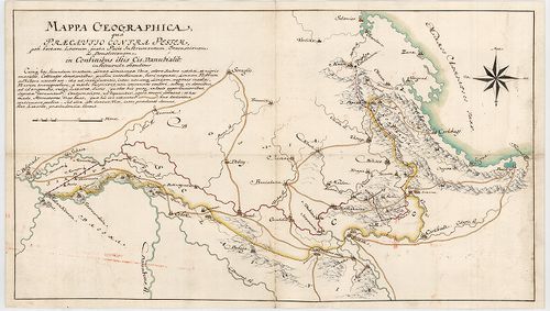
| Title | Mappa Geographica, qua Praecautio contra Pestem instituenda [...] ostenditur... |
| Main title | Földrajzi térkép, amelyen a pestis terjedésének megelőzésére hozandó intézkedéseket mutatjuk meg. Határtérkép. |
Contributor: MARSIGLI L F MÜLLER J C [...]
28. Mappa Geograph. Croatiae Inferior. Inter Unam, Colapim, et S... [B IX c 1427]
Institute and Museum of Military History •
B IX c
•
B IX Ausztria–Magyarország
•
B I–XV. Európa
| Title | Mappa Geograph. Croatiae Inferior. Inter Unam, Colapim, et Savum, sitt., qua ostenditur, quid demolitio Novi, importare possit... |
Contributor: MARSIGLI L F MÜLLER J C [...]
29. Mappa Geographica Lineae, ad Coranam, fl. Limitaneae, usque ... [B IX c 1428]
Institute and Museum of Military History •
B IX c
•
B IX Ausztria–Magyarország
•
B I–XV. Európa
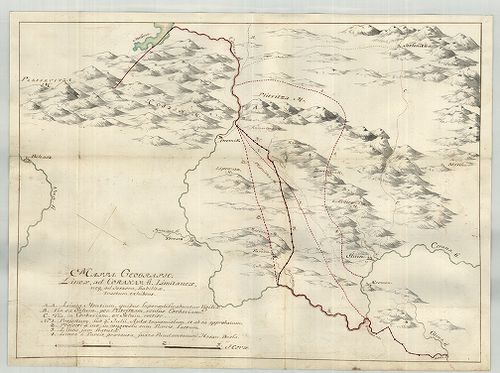
| Title | Mappa Geographica Lineae, ad Coranam, fl. Limitaneae, usque ad Jeszera [sic], stabilitae, tractum exhibens... |
| Main title | Földrajzi térkép, amely a Corana folyó mentén Jeszeraig futó végleges határszakaszt ábrázolja. Határtérkép. |
Contributor: MARSIGLI L F MÜLLER J C [...]
30. Mappa Limitanea Regni Croatiae... [B IX c 1429]
Institute and Museum of Military History •
B IX c
•
B IX Ausztria–Magyarország
•
B I–XV. Európa
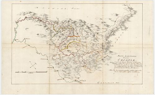
| Title | Mappa Limitanea Regni Croatiae... |
| Main title | Horvátország határtérképe... |
Contributor: MARSIGLI L F MÜLLER J C [...]
31. [Mappa Mercantilis] - Mappa Geographica facta in usum Commer... [B IX c 1408]
Institute and Museum of Military History •
B IX c
•
B IX Ausztria–Magyarország
•
B I–XV. Európa
| Title | [Mappa Mercantilis] - Mappa Geographica facta in usum Commerciorum. |
| Main title | Földrajzi térkép, amely kereskedők használatára készült.[Kereskedelmi térkép]. |
Contributor: MARSIGLI L F MÜLLER J C [...]
32. Budavár. Gróf Marsigli Alajos Ferdinand olasz hadi mérnök je... [H III c 146]
Institute and Museum of Military History •
H III c (1651–1700)
•
H III Újkori háborúk (1492–1789)
•
H Háborúk
| Title | Budavár. Gróf Marsigli Alajos Ferdinand olasz hadi mérnök jelentései és térképei Budavár 1684–1686-iki ostromairól, visszafoglalásáról és helyrajzáról. |
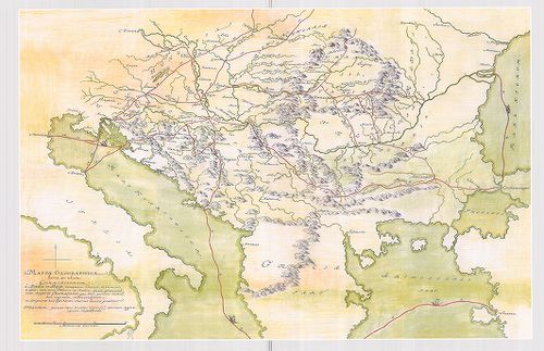
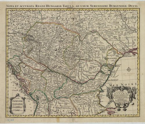
33. Tabula Hungaria et Regionum, quae praterae ab ea dependent, ... [B IX a 539/9]
Institute and Museum of Military History •
B IX a
•
B IX Ausztria–Magyarország
•
B I–XV. Európa
| Title | Tabula Hungaria et Regionum, quae praterae ab ea dependent, Delineata juxta magnum numerum annotationum… |
| Main title | Magyarország, a társországok és a Balkán-félsziget É-i államainak térképe 1720 körül. |
Technical features: Marsigli megfigyelései alapján Metsz Matthaus Seutter [...]
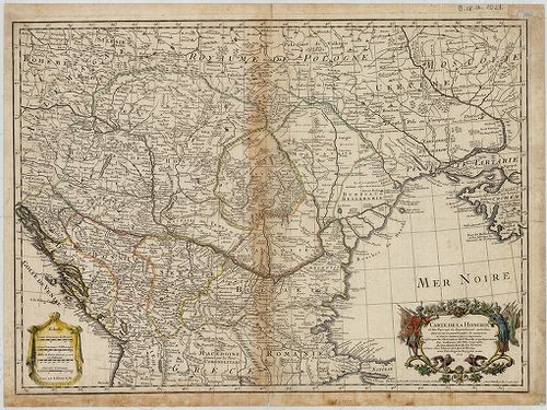
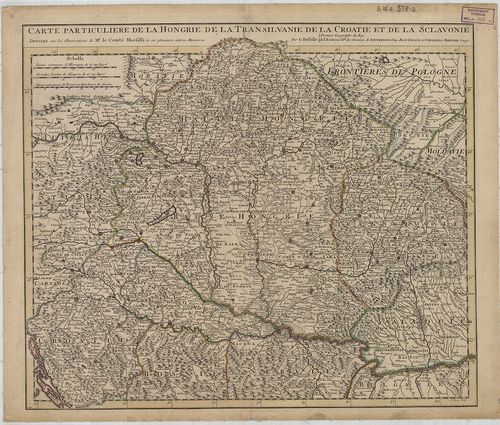
34. Carte Particuliere de la Hongrie de la Transilvanie de la Cr... [B IX a 539/1]
Institute and Museum of Military History •
B IX a
•
B IX Ausztria–Magyarország
•
B I–XV. Európa
| Title | Carte Particuliere de la Hongrie de la Transilvanie de la Croatie et de la Sclavonie. |
| Main title | Magyarország, Erdély, Horvát-Szlavónia térképe 1717-ben, tartományi határszínezés. |
Technical features: Marsigli megfigyelései és más memoárok alapján [...]
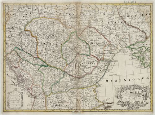
35. Carte de la Hongrie et des Pays qui en dependoient autrefois... [B IX a 1021]
Institute and Museum of Military History •
B IX a
•
B IX Ausztria–Magyarország
•
B I–XV. Európa
| Title | Carte de la Hongrie et des Pays qui en dependoient autrefois. |
| Main title | Magyarország és a társországok térképe. |
Technical features: Marsigli megfigyelései alapján Paris 1745 Delisle [...]
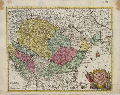
36. Le Royaume de Hongrie et des Pays qui en dependoient autreso... [B IX a 539/4]
Institute and Museum of Military History •
B IX a
•
B IX Ausztria–Magyarország
•
B I–XV. Európa
| Title | Le Royaume de Hongrie et des Pays qui en dependoient autresois… |
| Main title | Magyarország és a szomszédos területek térképe 1730 körül, tartományi határszínezés. |
Technical features: Marsigli és más szerzők megfigyelései alapján [...]
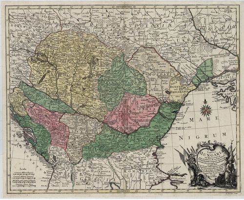
37. Carte Particuliere de la Hongrie de la Transilvanie de la Cr... [B IX a 539/2]
Institute and Museum of Military History •
B IX a
•
B IX Ausztria–Magyarország
•
B I–XV. Európa
| Title | Carte Particuliere de la Hongrie de la Transilvanie de la Croatie et de la Sclavonie. |
| Main title | Magyarország, Erdély, Horvát-Szlavónia térképe Delisle térképe alapján. |
Technical features: Marsigli megfigyelései és más memoárok alapján [...]
38. Tabula Hungaria et Regionum, quae praeterea ab ea dependent,... [B IX a 539/19]
Institute and Museum of Military History •
B IX a
•
B IX Ausztria–Magyarország
•
B I–XV. Európa
| Title | Tabula Hungaria et Regionum, quae praeterea ab ea dependent, Delineata juxta magnum numerum annotationum et mappas manuscriptas vel impressas… |
| Main title | Magyarország és a környező államok térképe a 18. században. |
Technical features: Marsigli megfigyelései alapján készült Metsz G [...]
39. Tabula Hungaria et Regionum quae praeterea ab ea dependent… [B IX a 512]
Institute and Museum of Military History •
B IX a
•
B IX Ausztria–Magyarország
•
B I–XV. Európa
| Title | Tabula Hungaria et Regionum quae praeterea ab ea dependent… |
| Main title | Magyarország és a társországok térképe 1760 körül. |
Technical features: Marsigli és G de L Isle [...]
40. Das Koenigreich Bosnien, und die Herzegovina (Rama) samt den... [S 68 - XII. - No. 60.]
National Archives of Hungary •
S 68 Festetics család (1645-1943)
•
S Családi fondokból kiemelt térképek (17. sz.-20. sz.)
•
S – Térképtár
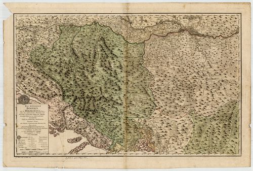
| Main title | Das Koenigreich Bosnien, und die Herzegovina (Rama) samt den angraenzenden Provinzen ... nach den militaerischen Handkarten des Prinzen Eugen der Grafen Kherenhüller, Marsigli und Pallavicini geographisch aufgetragen ... |
| Subject | XII. - No. 60. Bosznia, Hercegovina, Szerbia |